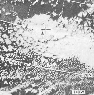
Figure 4-11.-Closed cells in a subtropical high.
MIDDLE CLOUDS IN RELATION
TO THE JETSTREAM
Jets indicate as much individuality with respect to
associated weather as do fronts. Because of the
individuality of jetstreams, and also because of the
individuality of each situation with respect to
humidity distribution and lower level circulation
patterns, statistically stated relationships become
somewhat vague and are of little value in forecasting.
SHORT-RANGE
EXTRAPOLATION
LEARNING OBJECTIVES: Compare short-range
extrapolation techniques for the movement of frontal
systems and associated weather.
The purpose of this section is to outline several
methods that are particularly suited to preparing
forecasts for periods of 6 hours or less. The
techniques presented are based on extrapolation.
Extrapolation is the estimating of the future value of
some variable based on past values. Extrapolation is
one of the most powerful short-range forecasting tools
available to the forecaster.
NEPHANALYSIS
Nephanalysis may be defined as any form of
analysis of the field of cloud cover and/or type. Cloud
observations received in synoptic codes permit only a
highly generalized description of the actual structure
of the cloud systems.
Few forecasters make full use of the cloud reports
plotted on their surface charts, and often, the first
consideration in nephanalysis is to survey what cloud
information is transmitted, and to make sure that
everything pertinent is plotted. For very short-range
forecast, the charts at 6-, 12-, and 24-hour intervals
are apt to be insufficient for use of the extrapolation
techniques explained in this chapter. Either
nephanalysis or surface charts should then be plotted
at the intermediate times from 3-hourly synoptic
reports or even from hourly sequences. An integrated
system of forecasting ceiling, visibility, cloud cover,
and
precipitation
should
be
considered
simultaneously, as these elements are physically
dependent upon the same synoptic processes.
With present-day satellite capabilities, it is rare
that a nephanalysis would be manually performed.
Instead, the surface analysis and satellite imagery
will be used together.
FRONTAL PRECIPITATION
For short-range forecasting, the question is often
not whether there will be any precipitation, but when
will it begin or end.
This problem is well suited to extrapolation
methods. For short-range forecasting, the use of
hourly nephanalyses often serve to “pickup” new
precipitation areas forming upstream in sufficient
time to alert a downstream area. Also, the thickening
and lowering of middle cloud decks generally indicate
where an outbreak of precipitation may soon occur.
Forecasting the Movement of Precipitation
Areas by Isochrones
The areas of continuous, intermittent, and
showery precipitation can be outlined on a large-scale
3-hourly or hourly synoptic chart in a manner similar
to the customary shading of precipitation areas on
ordinary synoptic surface weather maps. Different
types of lines, shading, or symbols can distinguish the
various types of precipitation. Isochrones of several
hourly past positions of the lines of particular interest
can then be added to the chart, and extrapolations for
several hours
4-9


