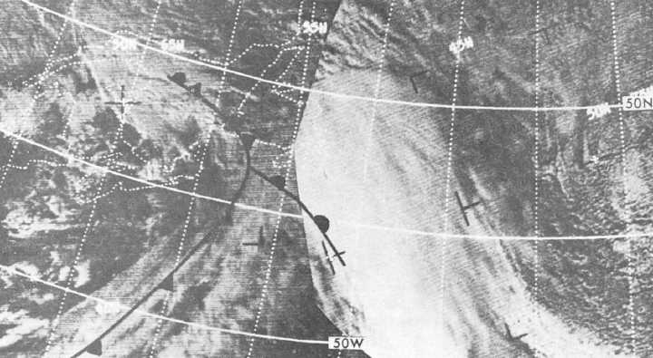
Figure 4-7.-Warm front satellite cloud imagery.
Orographic Barriers
In general, an orographic barrier increases the
extent
and
duration
of
cloudiness
and
precipitation on the windward side, and decreases
it on the leeward side.
AIR MASS CLOUDINESS AND
PRECIPITATION
If an air mass is lifted over an orographic
barrier, and the lifting is sufficient for the air to
reach its lifting condensation level, cloudiness of
the convective type occurs. If the air is
convectively unstable and has sufficient moisture,
showers or thunderstorms occur. The preceding
situations occur on the windward side of the
barrier.
Curvature (path of movement) of the flow aloft
also affects the occurrence of cloudiness and
precipitation. In a cool air mass, showers and
cumulus and stratocumulus clouds are found in
those portions of the air mass that are moving in a
cyclonically curved path. In a warm air mass,
cloudiness and precipitation will be abundant
under a current turning cyclonically or moving in
a straight line. Clear skies occur where a current
of air is moving from the north in a straight line or
in an anticyclonically curved path. Also, clear
skies are observed in a current of air moving from
the south if it is turning sharply anticyclonically.
Elongated V-shaped troughs aloft have cloudiness
and precipitation in the southerly current in
advance of the troughs, with clearing at and
behind the trough. These rules also apply in
situations where this type of low is associated with
frontal situations.
Cellular cloud patterns (open or closed), as
shown by satellite imagery, will aid the forecaster
in identifying regions of cold air advection, areas
of cyclonic, anticyclonic, and divergent wind flow.
Open Cellular Cloud Patterns
Open cellular cloud patterns are most
commonly found to the rear of cold fronts in cold,
unstable air. These patterns are made up of many
individual cumuliform cells. The cells are
composed of cloudless, or less cloudy, centers
surrounded by cloud walls with a predominant
ring or U-shape. In the polar air mass, the open
cellular patterns that form in the deep, cold air are
predominately
cumulus
congestus
and
cumulonimbus. The open cells that form in the
subtropical high are mainly stratocumulus,
cumulus, or cumulus congestus clusters. For open
cells to form in a polar high, there must be
moderate to intense heating of the air mass from
below.
4-6


