These storms (lows) are outbreaks on the polar
front or the generation or regeneration of a storm along
the trailing edge of an old front. The low pressure along
these fronts intensifies in certain areas as the front
surges southward ahead of a moving mass of cold polar
air. Much of the weather, especially the winter weather,
in the Temperate Zone is a direct result of these storms.
Air-mass weather also affects temperate climates.
Air-mass weather is the name given to all weather other
than the frontal weather in the temperate region.
Air-mass weather is the net effect of local surface
circulation, terrain, and the modifying effect of
significant water bodies.
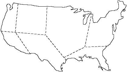
There are many subdivisions of weather regions in
the United States. For the purpose of this discussion, we
have divided the continental United States into seven
regions as indicated in figure 6-9.
Northwest Pacific Coast Area
The northwest pacific coast area has more
precipitation than any other region in North America.
Its weather is primarily the result of frontal phenomena,
consisting mainly of occlusions, which move in over
the coast from the area of the Aleutian low and
orographic lifting of moist, stable maritime air.
Predominant cloud forms are stratus and fog, which are
common in all seasons. Rainfall is most frequent in the
winter and least frequent in the summer.
Southwest Pacific Coast Area
The southwest pacific coast area experiences a
Mediterranean-type
climate
and
is
distinctively
different from any other North American climate. This
climate occurs exclusively in the Mediterranean and
southern California in the Northern Hemisphere. In the
Southern Hemisphere, it occurs over small areas of
Chile, South Africa, and southern Australia.
This climate is characterized by warm to hot
summers, tempered by sea breezes, and by mild winters
during which the temperatures seldom go below
freezing. Little or no rainfall occurs in the summer and
only light to moderate rain in the winter.
Cold fronts rarely penetrate the southwest pacific
coast region. The weather over this region is due to the
circulation of moist pacific air from the west being
forced up the slope of the coastal range. In the summer,
air is stable, and stratus and fog result. In the winter,
unstable air, which is forced over the mountain ranges
causes showers or snow, showers in the mountains.
Intermountain West Central Area
The intermountain west central area includes the
Great Plains region. This region is located east of the
Cascade and coastal ranges, west of the Mississippi
Valley, and north of the southwest desert area. The
climate is generally cold and dry in the winter, and
warm and dry in the summer. Most of the region is
6-26
WEST CENTRAL
INTERMOUNTAIN
CENTRAL PLAINS
NORTH
ATLANTIC
COASTAL
SOUTHEAST
AND GULF STATES
S. WEST DESERT
AND MOUNTAIN
S. WEST
PACIFIC
COAST
N. WEST
PACIFIC
COAST
AG5f 0609
Figure 6-9.—United States weather regions.


