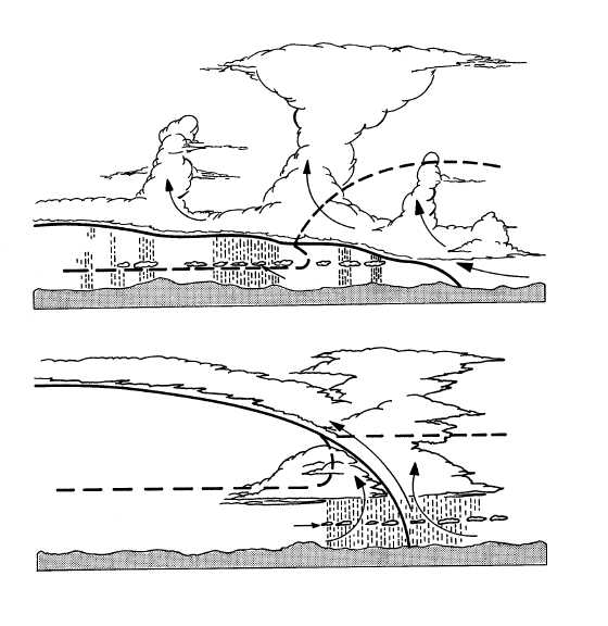
through it from the warm air mass above. If the
temperature is below 0°C, icing may occur; but
generally it is light (view A of fig. 4-43). The shallow
slope of an unstable stationary front results in a very
broad and extensive area of showers, fog, and reduced
visibility.
If the slope of an unstable stationary front is steep
and sufficient warm air is advected up the slope or the
front moves slowly toward the warm air mass, violent
weather can result (view B of fig. 4-43). Heavy rain,
severe thunderstorms, strong winds, and tornadoes are
often associated with this front. The width of the band
of precipitation and low ceilings vary from 50 miles to
about 200 miles, depending upon the slope of the front
and the temperatures of the air masses. One of the most
annoying characteristics of a stationary front is that it
may greatly hamper and delay air operations by
persisting in the area for several days.
REVIEW QUESTIONS
Q4-18. When a quasi-stationary front moves, if it
does, what is the normal speed?
Q4-19.
What type of weather is normally associated
with an unstable stationary front?
MODIFICATIONS OF FRONTS
LEARNING OBJECTIVE: Describe how
fronts are modified by their movement,
orographic features, and underlying surfaces.
The typical fronts we have just covered can and do
undergo modifications that strengthen or weaken them.
Such things as frontal movement, orographic effects,
and the type of surface the fronts encounter contribute
to the modification of fronts.
4-45
SCATTERED
THUNDERSTORMS
COLD AIR
A.
SHALLOW STATIONARY FRONT
0 C
O
AG5f0443
WARM AIR
TOWERING
CUMULUS
STRATOCUMULUS
0 C
O
SCUD
LINE SQUALL
ALTOCUMULUS
STRATUS OR
STRATOCUMULUS
COLD AIR
WARM
AIR
0 C
O
0 C
O
SCUD
B.
STEEP STATIONARY FRONT
Figure 4-43.—Types of unstable stationary fronts.


