Warm Fronts
When a warm front approaches a mountain range,
the upper section of the frontal surface is above the
effects of the mountain range and does not come under
its influence (view A of fig. 4-45). As the lower portion
of the frontal surface approaches the range, the
underlying cold wedge is cut off, forming a more or less
stationary front on the windward side of the range. The
inclination of the frontal surface above the range
decreases and becomes more horizontal near the
mountain surfaces, but the frontal surface maintains its
original slope at higher altitudes (view B of fig. 4-45).
While the stationary front on the windward side of the
range may be accompanied by prolonged precipitation,
the absence of ascending air on the leeward side of the
range causes little or no precipitation. The warm air
descending the leeward side of the range causes the
cloud system to dissipate and the warm front to travel as
an upper front.
Frontogenesis (the formation of a new front or the
regeneration of an old front) may occur in the
pressure-trough area that accompanies the front. The
frontal surface then gradually forms downward as the
frontal system moves away from the mountain and
extends to the earth’s surface again (views C and D of
fig. 4-45). The effect of the mountain range on a warm
front is to widen and prolong the precipitation on the
windward side of the range, while on the leeward side
the precipitation band is narrowed and weakened, or is
nonexistent.
Occluded Fronts
Mountain ranges have much the same effect on
occluded fronts as they do on warm and cold fronts.
Cold type occlusions behave as cold fronts, and warm
type occlusions behave as warm fronts. The occlusion
process is accelerated when a frontal wave approaches
a mountain range. The warm front is retarded; but the
cold front continues at its normal movement, quickly
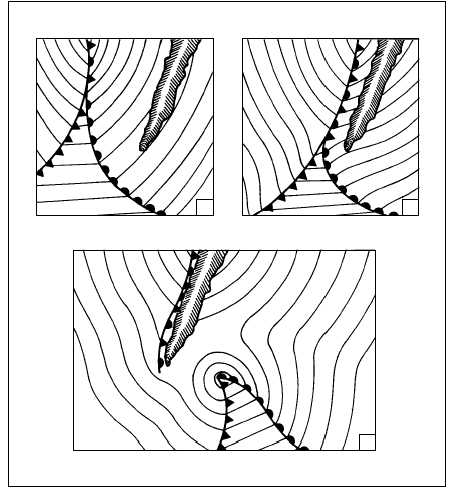
overtaking the warm front (views A and B of fig. 4-46).
4-48
A
B
C
AG5f0446
Figure 4-46.—Acceleration of the occlusion process and development of a frontal wave cyclone.


