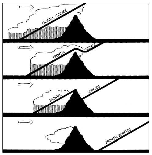
flow down the leeward side of the range. The warmer
air on the leeward side of the mountain is displaced by
the colder air mass. As this cold air descends the
leeward side of the mountain, the air warms
adiabatically (view A of fig. 4-44) and clearing occurs
within it. However, since the cold air is displacing
warm air, typical cold frontal clouds and precipitation
may occur within the warm air if the warm air is
sufficiently moist and conditionally unstable. In some
cases maritime polar air that has crossed the Rockies is
less dense than maritime tropical air from the Gulf of
Mexico that may lie just east of the mountains. If the
maritime polar air is moving with a strong westerly
wind flow and the maritime tropical air is moving with
a strong southerly wind flow, the maritime polar air
may overrun the maritime tropical air. This results in
extremely heavy showers, violent thunderstorms, and
possible tornadoes.
If COLDER stagnant air lies to the leeward side of
the mountain range, the cold front passing over the
mountain range does not reach the surface but travels as
an upper cold front (view B of fig. 4-44). Under this
condition, frontal activity is at a minimum. This
situation does not continue indefinitely; either the
stagnant air below mixes with the air above or the upper
cold front breaks through to the ground when the
stagnant surface air has warmed sufficiently. Then the
front returns to a normal classic front and begins to lift
the now warm air. This ultimately results in the
development of thunderstorms and squall lines (view C
of fig. 4-45). In the summer, this occurs frequently in
one form along the eastern United States. When a cold
sea breeze occurs and a cold front crosses the
Appalachian Mountains, the associated cold wedge of
on-shore flow forces the warm air in advance of the
cold front aloft, producing intense thunderstorm
activity.
Generally, the area of precipitation is widened as a
cold front approaches a mountain range. There is an
increase in the intensity of the precipitation and cloud
area on the windward side of the range and a decrease
on the leeward side.
4-47
A.
WARM
B.
COLD
WARM
C.
AG5f0445
WARM
COLD
COLD
COLD
WARM
WARM
D.
Figure 4-45.—Orographic effects on a warm front.


