Types For Observers has excellent photographs and
descriptions of these supplementary features.
CLOUD IDENTIFICATION
Since the only method at present to identify cloud
type is by visual identification, you must be familiar
with the characteristics of the various clouds. Although
NAVMETOCCOMINST 3141.2 and NAVMETOC-
COMINST 3144.1 present a good description of the
clouds present in the 27 states-of-the-sky, you should be
thoroughly familiar with the identification features of
each cloud type. Let’s take a closer look at some of the
important identification features of cloud genera.
Cumulus (CU)
Cumulus, translated from Latin, means "heap."
Heap aptly describes a cumulus cloud in most of its
stages. Since cumulus clouds form by convective
action, the height of their base above the surface is
directly related to the amount of moisture near the
surface. The higher the moisture content, the lower the
cloud base. Although the water droplets in cumulus are
very numerous, they are very small in the cloud’s early
stages. As a cumulus cloud continues to grow, the
number of large drops within the cloud increases. These
large drops may be precipitated from the cloud or may
continue to be suspended by the vertical air currents
within the cloud. Precipitation in the form of showers
occurs with cumulus clouds of moderate development.
Although this precipitation may be of moderate
intensity, its duration is usually short lived. These
clouds do not produce the heavy rain and high winds
that are associated with their bigger brothers, the
cumulonimbus.
Occasionally, the showers from cumulus clouds
evaporate before they reach the ground. This situation
is known as virga and is characterized by a dark "fuzzy"
area immediately below the nearly uniform base of the
cumulus cloud. This darker fuzzy area, caused by the
precipitation, decreases in intensity beneath the cloud
until it disappears (complete evaporation). When virga
consists of snow or ice crystals, the virga is not dark and
appears more "wispy." This is due to the greater
influence of the wind on the snow and ice crystals; the
precipitation trails appear to be bent by the wind.
Cumulus clouds produced by convective heating
develop in a distinct sequence. This is the primary
means by which convective clouds form within an air
mass. The cumulus clouds first appear as cumulus
humilis, and then develop into cumulus mediocris and
cumulus congestus. Although cumulus congestus may
continue to develop into cumulonimbus, the
cumulonimbus clouds are identified as a separate cloud
genus.
When cumulus clouds are formed by mechanical
lift, the sequence is the same. However, early stages of
development may not be apparent, especially if
stratiform clouds are already present.
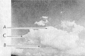
CUMULUS HUMILIS.—In the earliest stage of
development, cumulus usually forms in, and indicates,
good weather. A typical cumulus cloud is shown in
figure 1-7 in its formative stage. Point A shows the
clearly defined outline, the distinct white color, and the
characteristic "bulging" appearance. At point B, notice
the characteristic flatter and darker base. In this stage,
the cumulus is often called a "fair-weather cumulus" or
cumulus humilis.
CUMULUS MEDIOCRIS.—When cumulus
clouds continue to develop vertically, and reach a
moderate vertical extent, they are called cumulus
mediocris (fig. 1-8). Cumulus mediocris have small
cauliflower-like buildups, but rarely produce
precipitation other than virga.
CUMULUS CONGESTUS.—Cumulus clouds
that continue to develop and to reach moderate vertical
extent are called cumulus congestus. Congestus
generally means the sky is filled with clouds vertically,
rather than horizontally. These clouds are identified by
several layers of puffy, cauliflower-like buildups
Figure 1-7.—Cumulus humilis cloud.
1-9


