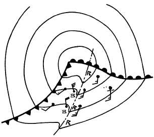
micro-high (small high) may form behind it. After
passage of the squall line, the wind backs to southerly
before the cold frontal passage. When the squall line
dissipates, severe weather may develop along the
fast-moving cold front.
Turbulence
is
severe
in
the
squall-line
thunderstorms
because
of
violent
updrafts
and
downdrafts. Above the freezing level, icing may occur.
Hail
is
another
possibility
in
the
squall-line
thunderstorm and can do extensive structural damage to
an aircraft. Under the squall line, ceiling and visibility
may be reduced because of heavy rain showers. Fog is a
rare occurrence because of the strong wind and gusts,
but it may be found in isolated cases. Tornadoes
frequently occur with squall lines when the warm air
mass is extremely unstable.
Great Plains Squall Lines
Not all instability lines that reach the mature or
squall-line stage develops in advance of a fast-moving
cold front. The Great Plains region of the United States
has a high frequency of these squall lines. The Great
Plains type of squall lines also develop in warm, moist,
unstable air masses. The necessary lifting or trigger
may be supplied by intense thermal heating, orographic
lifting,
or
convergent
winds
associated
with
a
low-pressure area.
FORMATION.—The Great Plains squall line
forms
when
an
extremely
unstable
condition
develops—normally in spring and summer. Extremely
unstable conditions exist when moist mP air cools in
the upper levels because of the evaporation of falling
precipitation. This cooler air aloft then moves over
warm moist mT air (or even warm, moist, highly
modified mP air) at the surface. If a sufficient trigger
such as a steep lapse rate of a lifting mechanism exists,
this extremely unstable situation rapidly develops into a
squall line.
WEATHER.—The weather associated with the
Great Plains squall line is the same as that found with
the prefrontal squall line. Because of the extreme
instability, tornadoes are a common occurrence.
REVIEW QUESTIONS
Q4-11. What is the pressure tendency with the
passage of a slow moving cold front?
Q4-12.
What is the normal slope of a fast moving cold
front?
Q4-13.
Where do prefrontal squall lines normally
form?
THE WARM FRONT
LEARNING OBJECTIVE: Describe the
characteristics and weather of warm fronts at
the surface and aloft.
A warm front is the line of discontinuity where the
forward edge of an advancing mass of relatively warm
air is replacing a retreating relatively colder air mass.
The slope of the warm front is usually between 1:100
and 1:300, with occasional fronts with lesser slopes.
Therefore, warm fronts have characteristically shallow
slopes caused by the effect of surface friction that
retards the frontal movement near the ground.
SURFACE CHARACTERISTICS
Warm fronts move slower than cold fronts. Their
average speed is usually between 10 and 20 knots. They
move with a speed of 60 to 80 percent of the component
of the wind normal to the front in the warm air mass.
The troughs associated with warm fronts are not as
pronounced as those with cold fronts and sometimes
make location difficult on the surface chart. The
pressure tendency ahead of the front is usually a rapid
or unsteady fall with a leveling off after frontal passage.
A marked decrease in isallobaric gradient is noticed in
the warm sector except when rapid deepening is taking
place. The wind increases in velocity in advance of
warm fronts because of an increase in pressure gradient
and reaches a maximum just prior to frontal passage.
The wind veers with frontal passage, usually from a
4-37
AG5f0435
Figure 4-35.—Typical isobaric pattern associated with a
prefrontal squall line.


