Intended Movement (PIM) on either a paper chart or in a
computer video display. These positions are used by the
forecaster to determine where the ship will be at any
given time, so the weather may be properly forecasted.
Your own ship’s PIM may be obtained from the
Quartermaster-of-the-Watch (QMOW), or the
navigator at a navigation briefing. The PIM may be in
the form of a series of latitude/longitude points, with
UTC times, or may be stated simply as, "making course
123 true, SOA 12 knots."
PIM TERMS AND DEFINITIONS
"Making course" means the ship is actually
traveling in that direction. This is different from
heading or steering course, which, due to the effects of
winds, seas, and currents, may be different from the
direction the ship is actually moving.
The term SOA means speed of advance, and has the
same meaning as speed made good—it is the speed the
ship is actually moving. This is not the same as
indicated speed—the speed the ship can make without
considering winds, seas, and currents, based on the
engine RPMs.
PLOTTING PIMs
When plotting PIMs, use a great circle chart or a
polar-stereographic background to plot great circle
routes. Plot all other routes on a Mercator chart or
display background.
Plot PIMs either on a paper chart or the computer
display by placing a dot or anx at the reported positions
and writing the UTC date-time group next to that
position. Indicate MOD LOC positions by drawing a
circle of the diameter reported, around the latitude and
longitude reported.
For direct routes, connect the
reported positions with straight lines; for coastal routes,
connect the positions with lines running parallel to the
coast. Connect reported rhumb-line route positions and
great-circle route positions (on a polar stereographic
chart) with straight lines. Mark the chart or display with
the name of the ship or the task force/task group name,
and the message date-time group of the MOVREP.
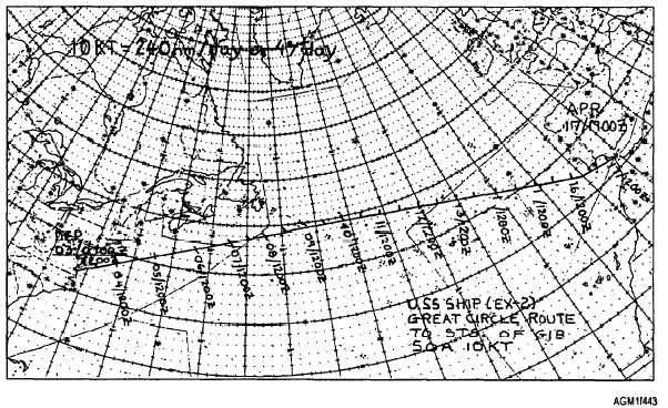
You will usually be rquired to indicate intermediate
times along the ship’s track, such as 12-hour increments
at 0000Z and 1200Z daily. To do this, measure the
length of the ship’s track or a segment of the track with a
set of dividers. Convert the length of the track to
distance in degrees by comparing it to the latitude scale
on the chart. Divide the distance, in degrees, by the
length of time, in hours, indicated for the track or
segment to obtain anticipated movement in degrees
latitude per hour. Then, multiply by the number of hours
in the desired increment to find the length of each
individual segment. Use the divider to transcribe these
segment lengths along the PIM track, and mark a short
line across the track at each intermediate distance.
Beside each mark indicate the date and time (fig. 4-43).
Figure 4-43.—Intermediate times marked on a ship’s PIM chart.
4-37


