During the winter, air resembling mT is
occasionally observed flowing inland over the gulf and
south Atlantic states. Generally the air that had a
relatively short trajectory over the warm waters off the
southeast coast is cP air. Clear weather usually
accompanies cP air in contrast to cloudy weather
accompanying a deep current of mT air. On surface
synoptic charts, the apparent mT air can be
distinguished from true mT air by the surface dew-point
temperature value. True mT air always has dew-point
temperature values in excess of 60°F. The highly
modified cP air usually has dew-point values between
50°F and 60°F.
NORTH AMERICAN AIR MASSES,
TRAJECTORIES, AND WEATHER
(SUMMER)
During the summer most of the United States is
dominated by either S or mT air, whereas Canada and
the northwestern United States are dominated by polar
air. Occasionally, tropical air is transported to the
Canadian tundra and Hudson Bay region.
Continental Polar (cP) Air in Summer
Continental polar (cP) air has characteristics and
properties quite different from those of its winter
counterpart. Because of the long days and the higher
altitude of the sun (as well as the absence of a snow
cover over the source region), this air is usually
unstable in the surface layers, in contrast to the marked
stability found in cP air at its source in winter. By the
time this air reaches the United States, it can no longer
be distinguished from air coming in from the North
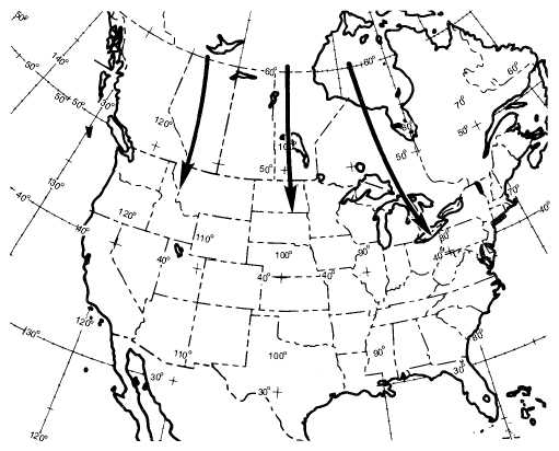
Pacific or from the Arctic Ocean. (See fig. 4-14.)
Clear skies or scattered cumulus clouds with
unlimited ceilings characterize this mass at its source
region. Occasionally, when this air arrives over the
central and eastern portion of the United States, it is
4-13
WARM OCEAN
COLD CONTINENT
FOG OR LOW STRATUS
AG5f0413
Figure 4-13.—mT (Gulf of Mexico or Atlantic) air of winter
moving northward over cold continent.
AG5f0414
cP
Figure 4-14.—Continental polar (cP) air in summer.


