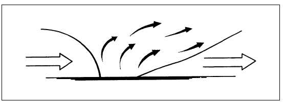
toward a warmer air mass. The cooler, denser air is
sliding under the warmer, less dense air displacing it
upward.
Warm Front
A warm front is one along which warmer air
replaces colder air. In this case, a warmer air mass is
moving toward a cooler retreating air mass. The
warmer, less dense air moves only toward and replaces
the colder, denser air if the colder air mass is also
moving.
Quasi-Stationary Front
This type front is one along which one air mass
does not appreciably replace the other. These fronts are
stationary or nearly so (speed under 5 knots). They can
move or undulate toward either the cold or warm air
mass.
Occluded Front
An occluded front is one where a cold front
overtakes a warm front, forcing the warm air upward.
The occluded front may be either a warm front or a cold
front type. a warm front type is one in which the cool air
behind the cold front overrides the colder air in advance
of the warm front, resulting in a cold front aloft. A cold
front type is one in which the cold air behind the cold
front under rides the warm front, resulting in a warm
front aloft.
RELATION OF FRONTS TO AIR
MASSES AND CYCLONES
LEARNING OBJECTIVE: Describe the
relationship of fronts to air masses and stable
and unstable wave cyclones.
RELATION OF FRONTS TO AIR MASSES
At this point you should have figured out that
without air masses there would be no fronts. The
centers of action are responsible for bringing the air
masses together and forming frontal zones.
The primary frontal zones of the Northern
Hemisphere are the arctic frontal zone and the polar
frontal zone. The most important frontal zone affecting
the United States is the polar front. The polar front is
the region of transition between the cold polar air and
warm tropical air. During the winter months (in the
Northern Hemisphere), the polar front pushes farther
southward, because of the greater density of the polar
air, than during the summer months. During the
summer months (in the Northern Hemisphere), the
polar front seldom moves farther south than the central
United States.
On a surface map a front is indicated as a line
separating two air masses; this is only a picture of the
surface conditions. These air masses and fronts extend
vertically. (See fig. 4-20.)
A cold air mass, being heavier, acts like a wedge
and tends to under run a warm air mass. Thus, the cold
air is below and the warm air is above the surface of
discontinuity. This wedge of cold air produces a slope
of the frontal surface. This slope is usually between 1 to
50 (1-mile vertical for 50 miles horizontal) for a cold
front and 1 to 300 (1-mile vertical for 300 miles
horizontal) for a warm front. For example, 100 miles
from the place where the frontal surface meets the
ground, the frontal surface might be somewhere
between 2,000 feet and 10,000 feet above Earth’s
surface, depending on the slope. The slope of a front is
of
considerable
importance
in
visualizing
and
understanding the weather along the front.
4-21
COLD-FRONT
SLOPE
COLD AIR
WARM AIR
WARM-FRONT
SLOPE
COLD AIR
AG5f0420
Figure 4-20.—Vertical view of a frontal system (clouds not shown).


