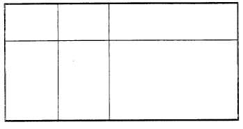
WMO
U.S.
STATION NAME
STATION
STATION
NUMBER
ID
723080
ORF
NORFOLKINTERNATIONAL
723085
NGU
NORFOLK NAS
723086
PHF
NEWPORT NEWS
723087
FAF
FORT EUSTIS/FELKER
723088
63W
MILFORD HAV EN CGS
(B)
(A)
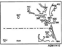
Figure 4-10.—View (A) is a section of a 1:4,000,000 scale DOD WPC (shown just smaller than actual size), and view (B), WMO
international station identification numbers and U.S. national station identification letters in the Norfolk, Virginia vicinity.
WMO block numbers are indicated on the plotting
charts, usually in large, pastel blue digits. And the
boundaries of each block are drawn as thin pastel blue
lines.
A complete numerical listing of WMO
block/station numbers is contained in the Master
Weather Station Catalog available via the Bulletin
Board System (BBS) from FNMOD Tinker AFB,
Oklahoma. The publication contains listings of country
names cross-referenced to block number. The
information provided for each station includes latitude,
longitude, elevation, information on the coordinates
and elevation of the upper-air observation site, and the
type of data and observations available. The codes used
in the listings are explained in the first section of the
publication.
Other station circles may be drawn on the same
chart, but identified with either a four-letter ICAO
station identifier, such as EGUN, outside of the United
States, or a three-letter (or letter/number) national
station identifier, such as NGU or 63W within the
United States.
ICAO Station Identifiers
Within most countries, except the United States,
airfields and their weather observation sites are
identified with a four-letter identifier assigned by the
International Civil Aviation Organization (ICAO). The
first letter is a regional identifier. The regional
identifier is used to identify specific groups of countries
in geographical areas of the world, such as M for the
Caribbean and Mexico, K for the United States, or P for
the Pacific. The second letter is specific to a particular
country in the region, although a single large country
may use several different letters as the second letter in
the airfield identifier. For example, in Southeast Asia,
Thailand uses ICAO four-letter identifiers beginning
with the region identifier V, followed by the country
identifier T. For example, Don Muong Airport,
Bangkok, Thailand is VTBD. No particular
relationship exists between the ICAO identifier and the
city name or airfield name.
Within the Unites States, most airfields that report
aviation weather use the three-letter national airfield
identifiers, such as DAB for Daytona Beach Regional
Airport, Daytona Beach, Florida, or BIS for Bismarck
Municipal Airport, Bismarck, North Dakota, as the
weather station identifier. Most of these identifiers,
assigned by the Federal Aviation Administration
(FAA), are similar to the city or airfield name. Naval
and Marine Corps air stations are nearly all identified by
a three-letter identifier beginning with an N. Many
automated weather reporting stations are identified by
three-letter/number combinations, such as 63W, as seen
in figure 4-10. Several years ago, the FAA assigned the
three-letter/number identifiers to heliports and airfields
that were not manned by air-traffic controllers. Even
though some of these stations do provide weather
observations, many do not. (Currently, the FAA assigns
unmanned airfields a combination two-letter, two-
number identifier.)
In the United States, ICAO identifiers were made
by simply prefixing the three-letter national identifier
with the ICAO region identifier K. Airfields equipped
to handle international air traffic use the ICAO
identifier as both an airfield identifier and as a
communications identifier for weather observations
4-11


