other. An estimate of the effects of each must be made
before a decision is reached.
When surface pressure falls occur near the center
and in the forward quadrants of the high, the high will
weaken.
When a cold high that is moving southward is
being heated from below, it will weaken, unless the
heating is compensated by intensification of the ridge
aloft. The amount of intensification can be determined
by correlating the contributions of height change at the
500-hPa level as progged and the change in thickness
as advected.
SATELLITE IMAGERY
The AG2 TRAMAN, volume 1, provides a detailed
discussion of satellite imagery analysis. It may be
beneficial to review Unit 10 before you read this
chapter.
Satellite imagery provides the forecaster with an
aid in forecasting the deepening of surface low-
pressure systems. In the following series of
illustrations, both visual and infrared imagery depicts
the cloud features over a 60-hour period during the
deepening of a low-pressure system. See figures 3-10
through 3-15.
In figure 3-10, the visual pass at noon local time
shows a large cloud mass with a low level vortex
centered near A. A frontal band, B, extends to the
southwest from the large cloud mass. The beginning of
a dry tongue is evident. An interesting cloud band, C,
which appears just north of the cloud mass, is of about
the same brightness as the major cloud mass.
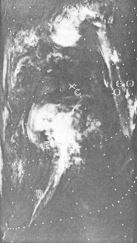
The infrared scan for midnight, figure 3-11, shows
the further development of the vortex with penetration
of the dry tongue. Low-level circulation is not visible,
but the brightness (temperature) distribution differs
from the visual picture. The detail within the frontal
band is apparent, with a bright cold line, DE, along the
upstream edge of the band. In all probability, this is
the cirrus generated by the convection near the polar
jetstream. The cloud band, C, from the previous
(daylight) picture is seen in the IR, and is composed of
lower clouds than would be anticipated from the video.
By the second noon (fig. 3-12), the vortex is clearly
defined, but again the spiral arm of the frontal band is
nearly saturated, with a few shadows to provide detail
on cloud layering. The National Meteorological Center
(NMC) operational surface analysis during this period
shows that the cyclone has deepened.
Figure 3-11.-Infrared, local midnight, first night.
In figure 3-13, the pass for the second midnight
shows the coldest temperatures form a hooked-shaped
pattern with the highest cloudiness still equatorward
of the vortex center at F. The granular gray-to-light-
gray temperature within the dry tongue area, G,
suggests cells that consist of cumulus formed from
stratocumulus, and small white blobs indicating
cumulus congestus.
The visual pass for the third noon (fig. 3-14) shows
the vortex to be tightly spiraled, indicating a mature
system. The frontal band is narrower than it was 24
hours earlier, with some cloud shadows present to aid
in determining the cloud structure. Surface analysis
indicates that the lowest central pressure of the
cyclone was reached approximately 6 hours prior to
this picture.
The final pass in this series (fig. 3-15) shows the
coldest temperatures completely surround the vortex.
The frontal band also shows the segmented nature of
the active weather areas within the band. A typical
vorticity
3-15


