If FUSING heights are indicated aloft over the
expected low position, the AMOUNT MUST BE
ESTIMATED to determine the ACTUAL height
difference to which the rule will apply. In some cases
the height rises aloft over the expected position of the
low may be quite large, indicating the development of a
high-latitude ridge aloft, which tends to block the
eastward progress of the low. This may result in rapid
deceleration of the low, with falling and/or recurvature
to the north. In such a case, the forecast position of the
low is revised in light of the changing circulation aloft.
The above technique works only when lows are
expected to move northeastward out of a heat source,
such as the Southern Plains. When a low moves into the
Southern Plains from the west or northwest, there is
frequently no accompanying cooling in the low
troposphere, since the low is moving toward the heat
source.
Some rules for the falling and deepening of surface
lows in relation to upper contours areas follows:
l Filling is indicated when a surface low moves
l Surface lows tend to fill when the associated
upper-level trough weakens.
l Surface lows tend to fill when they move toward
values of higher thickness lines.
l When the associated upper trough deepens, the
surface low also deepens.
l Surface lows deepen when they move toward
lower thickness values.
l Waves develop along fronts when the 700-hPa
windflow is parallel to the front, or nearly so.
l During periods of southerly flow at 700 hPa
along the east coast of the United States, secondary
storms frequently develop in the vicinity of Cape
Hatteras.
High Tropospheric Divergence in
Developing Lows
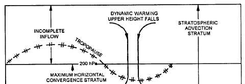
In the case of developing (dynamic) cyclones,
horizontal divergence is at a maximum in the 400- to
into or ahead of the major ridge position of the 500-hPa
200-hPa stratum, and the air above must sink and warm
level.
adiabatically to maintain equilibrium. See figure 3-8.
Figure 3-8.-Vertical circulation over developing low.
3-11


