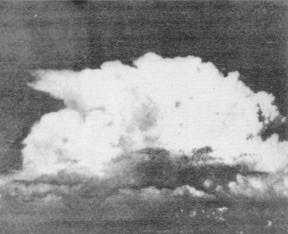
CUMULONIMBUS CAPILLATUS.—The
presence of the anvil top (incus) with or without cirrus
blow-off identifies a cumulonimbus capillatus (fig.
1-10), which is the most recognizable form of
cumulonimbus. These clouds, sometimes called
"anvil" clouds or "thunderheads," frequently produce
thunder, lightning, surface hail, strong and gusty
surface winds, and heavy rain.
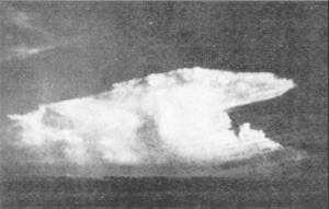
CUMULONIMBUS CALVUS.—A second
species of cumulonimbus, the cumulonimbus calvus,
lacks the familiar anvil top. Typically, it looks like an
extremely large cumulus congestus cell, with less
developed cumulus clouds surrounding it and appearing
to form a horizontal extension from the base of the
larger buildup (fig. 1-11). Although an anvil top,
thunder, or lightning need not be observed, the cloud is
classified by its size, development, and ominous
appearance. Typically, cumulonimbus calvus cells
have very dark gray bases. These clouds may later
develop an anvil top to become cumulonimbus
capillatus. If conditions are not favorable for continued
vertical development, cumulonimbus calvus clouds
may produce moderate to heavy shower activity as the
upward air currents in the cloud loose intensity.
REVIEW QUESTIONS
Q6. How many states-of-the-sky are internationally
recognized?
Q7. List the three general cloud forms.
Q8. Stable air is normally associated with what
general cloud form?
Q9. Describe the four processes that cool air by
lifting.
Q10. Mid-etage clouds in the temperate regions of the
earth are found between what levels?
Q11. Define cloud variety.
Figure 1-10.—Cumulonimbus capillatus (anvil cloud—note
that cirrus blow-off has not occurred.
Figure 1-11.—Cumulonimbus calvus cloud.
Q12. Most supplementary cloud features are
associated with what type of cloud?
Q13. The height of the base of cumulus clouds is
directly related to what factor?
Q14. What is a simple rule of thumb for classifying
cumulus congestus clouds as towering cumulus?
Q15. Cumulonimbus capillatus clouds are identified
by what distinguishing feature?
SUPPLEMENTAL FEATURES.—Many
supplemental cloud features of cumulonimbus clouds
indicate the stage of development or the potential
severity of the “storm.”
Light precipitation can begin to fall while the cloud
is still increasing in size. Heavy precipitation indicates
the cell has slowed or stopped increasing in height.
With the beginning of heavy precipitation, the cloud
base becomes rougher and less clearly defined.
Smaller, ragged, or fragmented clouds are frequent
under the base of the dissipating CB cell. These ragged
cloud elements are the species cumulus fractus (fig.
1-12) if they are more or less in individual elements, or
stratus fractus if they form a mostly continuous layer.
Collectively, the layer of fragmented elements is called
pannus—a supplemental cloud feature. Cumulus
fractus or stratus fractus clouds, often called "scud,"
usually are associated with falling precipitation or
found in the vicinity of numerous showers. Pannus may
exhibit very rapid movement under the CB cell base,
with individual elements moving in a radically different
direction than that of the CB cell. For example, it would
not be uncommon to see a CB cell moving toward the
northeast, with a low layer of pannus moving toward the
south.
1-12


