Both types of convective thunderstorms occur in
Florida. The anticyclonic circulation around the
Bermuda high advects moist air over the land surface of
Florida in its easterly flow. Thunderstorms off the East
Coast of Florida at night occur when this easterly flow
passes over the warm axis of the Florida current. In
those areas where the air is cooler than the water below
it, the air is heated and convective currents (lifting)
begin. Any nocturnal cooling of the easterly flow aloft
aids in establishing the unstable lapse rate necessary for
thunderstorm development. After sunrise, the air is
heated and becomes warmer than the water, thereby
destroying the balance necessary to sustain or build
similar storms. As the day progresses, the land surface
becomes considerably warmer than the air. Convective
currents again result, and Florida’s common afternoon
thunderstorms are observed. After sunset the land
cools, convective currents cease, and the thunderstorms
dissipate. The apparent movement of the storms to sea
at night, and to shore during the day, is in reality the
reformation of storms in their respective areas. As a
general rule, convective thunderstorms are scattered
and easily recognized. They build to great heights, and
visibility is generally excellent in the surrounding area.
Orographic.—Orographic thunderstorms form in
mountainous
regions,
particularly
adjacent
to
individual peaks. A good example of this type of storm
occurs in the northern Rocky Mountain region. When
the circulation of the air is from the west, moist air from
the Pacific Ocean is transported to the mountains where
it is forced aloft by the upslope of the terrain. If the air is
conditionally unstable, this upslope motion causes
thunderstorm activity on the windward side of the
mountains. This activity may form a long, unbroken
line of storms similar to a cold front. The storms persist
as long as the circulation causes an upslope motion.
They tend to be more frequent during afternoon and
early evening when convective lifting coincides with
the mechanical lifting of the terrain.
LIGHTNING
Lightning is obviously the most spectacular of
electrometeors
and
is
directly
related
to
the
thunderstorm even though classified independently. It
is the bright flash of light accompanying a sudden
electrical discharge. Most lightning has its beginning in
clouds; however, it generates from high structures on
the ground and mountains, although much less
frequently.
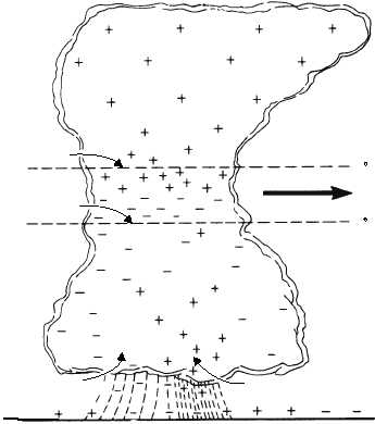
The thunderstorm changes the normal electric
field, in which the ground is negatively charged with
respect to the air above it. Because the upper portion of
the thunderstorm cloud is positive and the lower part is
negative, the negative charge induces a positive charge
on the ground. The distribution of the electric charges
in a typical thunderstorm is shown in figure 5-17. The
5-22
AG5f0517
DIRECTION
OF MOVEMENT
15 F
32 F
SMALL CENTER OF
POSITIVE CHARGE
AREA OF
NEGATIVE RAIN
POSITIVE
CHARGE
CENTER
NEGATIVE
CHARGE
CENTER
SURFACE
Figure 5-17.—Location of electric charges inside a typical thunderstorm cell.