DMSP SATELLITES
DMSP satellites are polar-orbiting satellites
managed by the Department of Defense that provide
very high-resolution imagery. These satellites can
provide real-time worldwide support to operating
forces for both shipboard and selected shore sites.
Near real-time (stored) environmental imagery can
also be provided by the Fleet Numerical Meteorology
and Oceanography Command (FNMOC) at Monterey,
California. Because imagery from DMSP satellites is
encrypted for transmission, special processing
equipment is required for download.
Each direct transmission received from DMSP
contains two channels, visible and infrared. The
channels are transmitted so that one channel will
provide "fine" data (0.56 km resolution) and the other
will provide "smooth" data (2.7 km resolution).
Unique sensors aboard DMSP satellites allow for the
collection of visual imagery at night by using lunar
illumination. The determination of channel
assignment is made by the Air Force Weather Agency
located at Offutt AFB, Nebraska.
DMSP satellites also have a special passive
microwave sensor known as a SSM/I (Special Sensor
Microwave/Imager).
The SSM/I measures thermal
energy emitted and reflected by the earth’s surface and
atmosphere by using the microwave portion of the
electromagnetic spectrum. SSM/I data is particularly
useful in water vapor and sea ice analysis. In addition,
wind speeds over ocean areas can be estimated by
evaluating the brightness temperatures of the white
caps of the waves. DMSP satellites are launched as "F"
series satellites (F-12, F-13, etc.).
A few satellites are equipped with a high-
frequency radar device known as a scatterometer. A
The WWW Global Observation System
scatterometer measures reflected microwave signals
from ocean waves. This data is then used to estimate
low-level wind speed and direction over data sparse
ocean areas.
Scatterometry data is available from
FNMOC.
FOREIGN SATELLITES
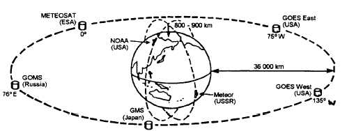
Several other countries also support active
meteorological satellite programs. China operates a
geostationary satellite called the Fengyun. Russia has
Meteor polar-orbiting satellites and GOMS
geostationary satellites in service. They also support a
joint project with India that has a geostationary
satellite—the INSAT, in place over the Indian Ocean.
Japan supports a geostationary satellite called the GMS
over the western Pacific Ocean. In Western Europe,
several nations jointly support the European Space
Agency (ESA). ESA maintains a geostationary
meteorological satellite called METEOSAT in place
over the Mediterranean region. Figure 1-9 shows the
global-scale monitoring program of the World
Weather Watch Global Observation System.
New satellites are routinely placed in orbit to
replace older satellites as they wear out and fail. Each
new satellite usually incorporates new technology and
may provide slightly higher image resolution or an
entirely new type of sensor. As you read this, the
satellites just mentioned may be out of service and
replaced by newer models.
Information concerning the operational status of
all environmental satellites is available via the Internet
at the NOAASIS world wide web site operated by
NOAA/NESDIS. This site provides updated position
data for geostationary satellites as well as tracking
information bulletins for polar-orbiting satellites. The
AGM3f109
Figure 1-9.—The World Weather Watch Global Observation System.
1-8


