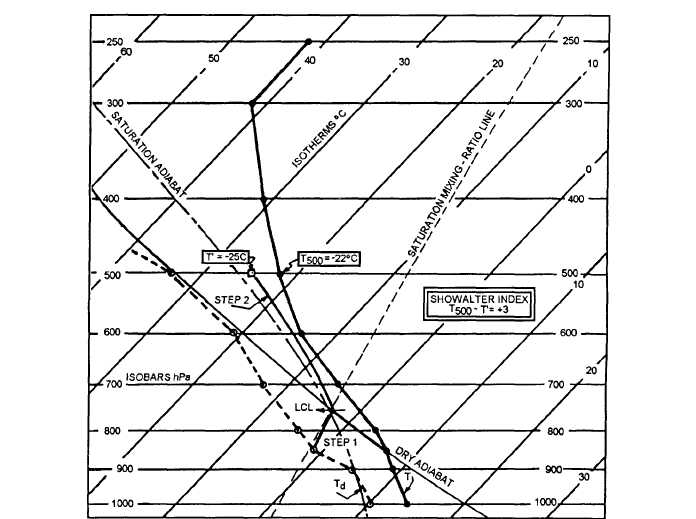
Figure 5-7 shows the computation of the SSI.
For forecasting purposes, the significance of the
index values to forecasting is as follows:
l When the index is +3°C or less, showers are
probable, and some thunderstorms may be expected in
the area.
l The chance of thunderstorms increases rapidly
for index values in the range of +1°C to -2°C.
. Index values of -3°C or less are associated with
severe thunderstorms.
. When the value of the index is below –6°C, the
forecaster should consider the possibility of tornado
occurrence. However, the forecasting value of all index
categories must, in each case, be evaluated in the light
of the moisture content of the air and of other synoptic
conditions.
FORECASTING MOVEMENT OF
THUNDERSTORMS
Radar can be an invaluable aid in determining the
speed and the direction of movement of the
thunderstorm. Sometimes it is desirable and necessary
to estimate the movement from winds aloft. There is no
completely reliable relationship between speed or
direction of the winds aloft in forecasting thunderstorm
movement. However, one study reveals that there is a
marked tendency for large convective rainstorms to
move to the right of the wind direction in the mean cloud
layer from 850 to 500 hPa (or the 700-hPa wind) with a
deviation of about 25 degrees. There appears to be little
correlation between wind speed and speed of movement
at any level, although the same study mentioned above
revealed that 82 percent of the storms move within plus
or minus 10 knots of a mean speed of 32 knots.
25NP0048
Figure 5-7.-Computation of the Showalter Stability Index (SSI).
5-10


