original level moist adiabatically, By connecting the
points on a sounding, a wet-bulb curve can be
constructed.
If the wet-bulb curve slopes to the right with
increasing altitude, the potential wet-bulb temperature
increases with height, and the layer is potentially stable.
If it slopes to the left with increasing height, more than
the saturation adiabats, the layer is potentially unstable.
If none of the potential curves intersect the sounding,
thunderstorms are not likely to occur.
AIR-MASS THUNDERSTORMS
This method is a reasonably simple method for
forecasting air-mass thunderstorms in the Eastern
United States. It does require prediction of short-range
changes in the vertical distribution of temperature and
moisture.
l The first consideration is to eliminate those areas
whose soundings disclosed one or more of the following
moisture inadequacies:
. The Dewpoint depression is 13°C or more at any
level from 850 through 700 hPa.
. The Dewpoint depression sum is 28°C or more
at 700- and 600-hPa levels.
. There is dry or cool advection at low levels.
. The surface dewpoint is 60°F or less at 0730 local
with no substantial increase expected before early
afternoon.
l There is a lapse rate of 21°C or less from 850 to
500 hPa.
. There is a freezing level below 12,000 feet in an
unstable cyclonic flow, producing only light showers.
After eliminating all soundings that meet one or
more of the previous six conditions, you should use the
following parameters to make the forecast.
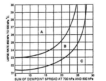
. The lapse rate between 850 and 500 hPa.
. The sum of the dewpoint depressions at 700 and
600 hPa in degrees C.
NOTE: The lapse rate is the difference in
temperature between these two pressure levels. For
example, if the temperature at 850 hpa was 15°C and at
500hPa it was –10°C, the difference would equal 25°.
These two computations are used as arguments for
the graph in figure 5-5.
25NP0046
Figure 5-5.-Local area thunderstorm graph. Area “A” iS
isolated thunderstorms, with a 12 to 1 chance of at least one
rain gauge in dense network receiving rain. Area “B” is
scattered thunderstorms, with a 4 to 1 chance of reported
rain. Area “C” is no rain.
One further condition for the development of
thunderstorms is the absence of large anticyclonic wind
shear, which is measured at 850 hPa. No horizontal
shear at this level may exceed 20 knots in 250 miles
measured toward the low-pressure area from the
sounding station.
Figure 5-6 illustrates how this
measurement is made.
STABILITY INDEXES AS AN INDICATION
OF INSTABILITY
The overall stability or instability of a rawinsonde
sounding is sometimes conveniently expressed in the
form of a single numerical value called the stability
index. Such indexes have been introduced mainly as
aids in connection with particular forecasting
techniques.
Most of the indexes take the form of a
difference in temperature, dewpoint, wet-bulb
temperature, or potential temperature in height or
pressure between two arbitrarily chosen surfaces.
These indexes are generally useful only when
combined, either objectively or subjectively, with other
data and synoptic considerations. Used alone, they are
less valuable than when plotted on stability index charts
and analyzed for large areas. In this respect they have
the value of alerting the forecaster to those soundings,
routes, or areas that should be more closely examined
by other procedures.
5-8