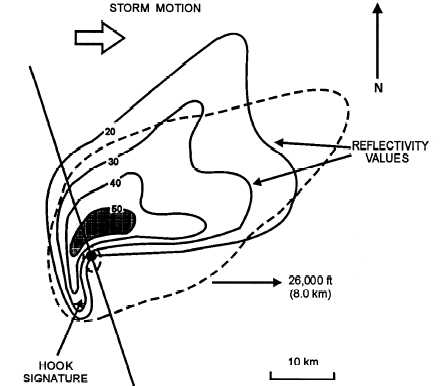
form there. Figure 2-33 exhibits a classic hook
signature.
Hook detection is difficult under any
circumstances. Hooks are a small, short-lived feature,
often obscured by surrounding storm mass. Due to
beam broadening, distant hooks might be missed
altogether. While the vertical extent of a tornado might
exceed 35,000 feet, hooks are most commonly
observed on radar at lower elevation angles.
WEAK ECHO REGIONS (WER).—A weak
echo region is that portion of a storm exhibiting below
normal returns. WERs are normally found at the
storm’s core. They are formed from the absence of
water droplets and hail. As intensifying updrafts lift
mass to greater heights, they create an area that is void
of scatterers (no reflectivity). This area of weak echoes
appears hollow within the storm. Notice the weak echo
region forming in the lower portions of figure 2-34,
view (A).
BOUNDED WEAK ECHO REGION
(BWER).—If a WER continues to develop, it will
eventually become bounded on all sides by much
stronger reflectivities. This occurs as water droplets
and hail exit the column at great heights, encircling the
updraft core as they fall back toward earth. Bounded
weak echo regions (BWERs) generally confirm storm
development and imply a transition to severe status
(fig. 2-34, view B).
LINE ECHO WAVE PATTERN (LEWP).—A
LEWP is simply a line of convective echoes that has
become subjected to uneven acceleration. When this
occurs, some portion of the line is propelled faster than
other portions, causing the line to bend or arch.
Because of accelerated movements, severe weather is a
regular feature normally occurring ahead of LEWP, at
and slightly south of the crest. With this in mind,
position "2" in figure 2-35 stands at great risk of these
fast-moving storms. The speed of the LEWP itself is a
good indicator of its severity.
STRONG REFLECTIVITY GRADlENTS.—
From a radar perspective, monitoring rapid changes
can best be accomplished by monitoring reflectivity
gradients (transition zones). For instance, if the
temperature in Chicago is 55°F and the temperature in
Biloxi is 65°F, the thermal gradient between these two
cities is weak. However, if this same amount of change
occurred between New Orleans and Biloxi, the
gradient would be much stronger. For radar purposes,
reflectivity gradients illustrate the sharpness, or
contrast, between a storm and its surroundings. The
sharper the gradient, the greater potential for severe
weather. Enhanced resolution, color, and digitized
displays make reflectivity gradients more observable
than ever.
AGM3F233
Figure 2-33.—Thunderstorm cell exhibiting a classic hook signature.
2-36


