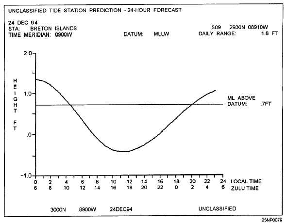
Table 8-1 shows an example output of a 24-hour
time/height graph.
It is displayed if the prediction
length is 1 day and a tabular output is selected Figure
8-1 shows an example output of a geographic display.
An X placed in the column labeled “GEOGRAPHIC”
on the “TIDAL STATION SELECTION” input screen
sends the user directly to the Tides Geographic Display.
NAVAL SEARCH AND RESCUE
(NAVSAR)
LEARNING OBJECTIVES
Identify
applications, limitations, and assumptions of
the NAVSAR product. Interpret the three
NAVSAR outputs.
The NAVSAR program provides search assistance
with two main functions:
1.
2.
Search Object Probability of Location Map
Recommended Search Plan
Both functions use environmental data to compute
the search object’s drift from distress time to determine
the area of the search where the object maybe found.
Function (1) divides the area into several cell areas of
equal size, and ranks them according to probability y of
search object containment. The second function
provides a search plan by determining either the search
asset on-station durations or the probability of search
success or search effort for cell areas.
NAVSAR auxiliary functions include organizing
and storing environmental and search object scenario
data on a status board, and computing immersion
survival time.
APPLICATION
NAVSAR provides information and planning
assistance to the search mission coordinator (SMC)
during search and rescue incidents at sea. NAVSAR is
designed to assist the SMC in deciding where to search
for a target, how many assets to commit to a search, and
how to assign those assets to maximize their
effectiveness.
Table 8-1.-Example Output of a 24-hour Tide Time/Height Graph
8-2


