PLOTTING CHEMICAL
CONTAMINATION DATA
Plotting chemical contamination areas is easy once
you understand the terms and the contents of a chemical
downwind message. Normally. the military grid
squares contaminated by a chemical weapon are
provided in element PAPA-ALFA of the chemical
downwind message. In a NAV NBC 3 CHEM message,
the contaminated area boundary positions should be
provided in degrees, minutes, and seconds (DMS). A
better picture of the contaminated area is constructed
using other parameters contained in the message. From
the NAV NBC 3 CHEM message, check element
ZULU-BRAVO to determine the type and case of the
attack. Element ZULU-ALFA contains environmental
information, and, on occasion, plain language may be
used in lieu of the meteorological reporting code. Now
let’s discuss the methods used to plot initial
contamination for circular, triangular, and double-
triangular hazard areas.
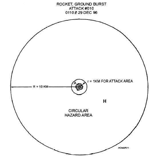
Circular Hazard Area
When winds are 5 knots or less in a type A-case (a)
or a type B-case (a), case (b), or case (c) attack, the
attack area is plotted as a circular hazard area. The
important factor is that the prevailing wind speed is 5
knots or less. In both type A-case (a) and type B-case (a)
attacks, the attack area is drawn as a 1/2-nautical-mile-
radius (1-kilometer-radius) circle around the location
where the chemical agent was deployed. In a type B-
case (b.) attack, the attack area is drawn as a 1/2- to 1-
nautical-mile-radius circle centered on the attack site
and in a type B-case (c), the attack area is drawn larger
than a 1-nautical-mile radius, depending on the type of
attack. In all of these situations, the hazard area is a 10-
kilometer-radius circle around the attack area for
Figure 5-11.—Circular hazard area. Plotted type B-case (a) chemical attack, land. Wind speed 10 KPH/5 kt or less.
5-14