ground forces, and a maximum of 15-nautical-mile
radius for Naval Forces.
From the NAV NBC 3 CHEM message, element
FOXTROT, locate and mark the attack coordinates on
your chart. Using a compass, set the distance between
the points to 30 seconds of latitude (1/2 nautical mile),
and draw a circle of this radius around the detonation
point, Label the area within this circle "A," for the
attack area. Then set the compass spacing to 15
minutes of latitude. and draw a second circle with that
radius around the detonation point.
Label the area
within this circle as "H," for the hazard area. Near the
circle, you should note the attack serial number and the
date-time of the attack. The NAV NBC 3 CHEM
message should either be kept with the chart or all of
the other information should be noted on the chart
(fig. 5-11).
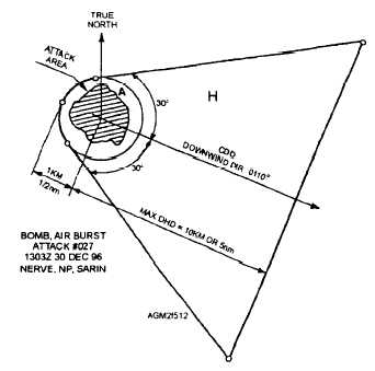
Triangular Hazard Area
When the winds are greater than 5 knots in a type A-
case (b) or type B-case (a) or case(b) attack, the plotted
hazard area will generally be a triangular pattern with a
circular attack area at the apex. The area is plotted as
follows:
1. From the NAV NBC 3 CHEM message, locate
the detonation point and mark this on your chart.
2. Now draw a light line through the point in the
direction given by the chemical downwind direction
(element YOKE). The line should extend through the
point for just over 1 nautical mile in the upwind
direction and up to 27 nautical miles in the downwind
direction, as long as the downwind hazard distance
(DHD).
3. From element ZEBRA-BRAVO, obtain the
DHD. Measure the DHD from the center of the
detonation downwind on the CDD line, and mark the
distance on the line.
4. Now use a compass to draw a 1/2 nautical mile
radius circle around the detonation point for either a
type A, case (b) or a type B, case (a) attack, or a 1
nautical mile radius circle for a type B, case (b) attack.
Label the area within the circle "A," for attack area.
5. From element ZEBRA-BRAVO, determine the
half-sector angle (HSA). If not given, the HSA is 30
degrees. Using a protractor on the segment of the CDD
line on the upwind side of the detonation point, and the
HSA angle, draw two radial lines tangent to the attack
area boundary circle: one at the HSA angle to the left of
the CDD line, the second at the HSA angle to the right of
the CDD line (fig. 5-12).
6. Now draw a line perpendicular to the CDD line
at the downwind hazard distance (DHD) marked earlier.
7. Label the triangular area extending downwind
from the attack area as "H," for hazard area.
8. Transfer all information from the NAV NBC 3
CHEM message to the chart.
NOTE: Instead of using a protractor to measure the
HSA angles, you may construct a reusable template
with 20-, 30-, and 35-degree HSA angles. Instructions
for construction and use of the template are provided in
the ATP-45.
Double-Triangular Hazard Area
When chemical contamination is dispersed over an
elongated area, such as would occur during an aircraft
spray attack, the resulting hazard area is plotted as two
connected triangular areas. In the case of an aerial spray
attack, it is assumed that the width of attack area is
greater than 2 kilometers (1 nautical mile) wide.
Normally, only ground-contaminating agents are used
with an aerial spray.
Once the agent settles on the
ground, the vapor released by the liquid or solid agent
drifts downwind. This hazard area is normally
associated with a type B-case (c) chemical attack.
When the attack location is provided as a series of
coordinates in element FOXTROT, or two coordinates
Figure 5-12.—Triangular hazard area. Plotted type A-case
(b) chemical attack.
5-15