The sea breeze usually begins during midmorning
(0900-1100 local time) when the land areas become
warmer than adjacent ocean waters (see fig. 3-25). This
temperature difference creates an area of slightly lower
surface pressures over land compared to the now cooler
waters. The result is a wind flow from water to land.
The sea breeze starts with a shallow flow along the
surface; however, as maximum heating occurs, the flow
increases with height. The height varies from an
average of 3,000 feet in moderately warm climates to
4,500 (or more) in tropical regions. The effects of the
sea breeze can be felt as far as 30 miles both onshore
and offshore. In extreme cases, the sea breeze is felt 100
miles inland depending upon terrain. By mid afternoon
(maximum heating) the sea breeze will reach its
maximum speed and may be strong enough to be
influenced by the Coriolis force, which causes it to flow
at an angle to the shore. The sea breeze is most
pronounced in late spring, summer, and early fall when
maximum temperature differences occur between land
and water surfaces. A decrease in temperature and an
increase in humidity and wind speed mark the start of a
sea breeze.
The sea breeze continues until the land area cools
sufficiently to dissipate the weak low pressure. After
sunset, the land cools at a faster rate than the adjacent
waters and eventually produces a complete reversal of
the winds. As the land continues to cool through the
evening hours, a weak area of high pressure forms over
the land. The water area, with its warmer temperatures,
has slightly lower pressure and again a flow is
established; however, the flow is now from land to
water (offshore). (See fig. 3-25.)
The land breezes, when compared to the sea
breezes, are less extensive and not as strong (usually
less than 10 knots and less than 10 miles offshore). This
is because there is less temperature contrast at night
between land and water surfaces as compared to the
temperature contrast during daytime heating. Land
breezes are at maximum development late at night, in
late fall and early winter. In the tropical land regions,
the land and sea breezes are repeated day after day with
great regularity. In high latitudes the land and sea
breezes are often masked by winds of synoptic features.
WINDS DUE TO LOCAL COOLING AND
HEATING
In the next sections we discuss tertiary circulations
due to local cooling and heating effects. Under normal
circumstances, these winds attain only light to
moderate wind speeds; however, winds often occur in
and near mountain areas that have undergone dramatic
changes in normal character. At times, mountain areas
tend to funnel winds through valleys and mountain
passes. This funneling effect produces extremely
dangerous wind speeds.
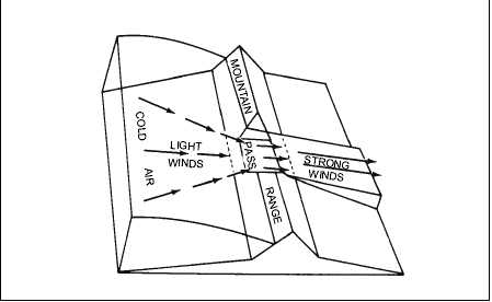
FUNNEL EFFECT
Winds blowing against mountain barriers tend to
flatten out and go around or over them. If a pass or a
valley breaks the barrier, the air is forced through the
break at considerable speed. When wind is forced
through narrow valleys it is known as the funnel effect
and is explained by Bernoulli’s theorem. According to
Bernoulli’s
theorem,
pressures
are
least
where
velocities are greatest; likewise, pressures are greatest
where velocities are least. This observation is true for
both liquids and gases. (See fig. 3-26.)
3-23
HIGH
PRESSURE
LOW
PRESSURE
AG5f0326
Figure 3-26.—Strong wind produced by funneling.


