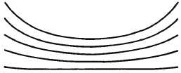
time the tropopause is reached. The subtropical highs
are good examples of this type of high. Therefore,
anticyclones found in tropical air are always warm core.
Examples of warm core highs are the Azores or
Bermuda High and the Pacific High.
VERTICAL STRUCTURE OF LOW-PRESSURE
SYSTEMS
Low-pressure systems, like high-pressure systems,
are generally a reflection of systems aloft. They, too,
experience shifts in location and changes in intensity
and shape with height. At times, a surface system may
not be evident aloft and a well-developed system aloft
may not reflect on a surface analysis.
Cold Core Lows
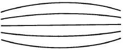
The cold core low contains the coldest air at its
center throughout the troposphere; that is, going
outward in any direction at any level in the troposphere,
warmer air is encountered. The cold core low (figure
3-20)
increases
intensity
with
height.
Relative
minimums in thickness values, called cold pools, are
found in such cyclones. The temperature distribution is
almost symmetrical, and the axis of the low is nearly
vertical. When they do slope vertically, they slope
toward the coldest temperatures aloft. In the cold low,
the lowest temperatures coincide with the lowest
pressures.
The cold low has a more intense circulation aloft
from 850 to 400 millibars than at the surface. Some
cold lows show only slight evidence in the surface
pressure field that an intense circulation exists aloft.
The cyclonic circulation aloft is usually reflected on the
surface in an abnormally low daily mean temperature
often
accompanied
by
instability
and
showery
precipitation. A cold core low is accompanied by a low
warm tropopause. Since the pressure surfaces are close
together, the tropopause is reached at low altitudes
where the temperature is relatively warm. Good
examples of cold core lows are the Aleutian and
Icelandic lows. Occluded cyclones are generally cold
core in their later stages, because polar or arctic air has
closed in on them.
At high latitudes the cold pools and their associated
upper air lows show some tendency for location in the
northern
Pacific
and
Atlantic
Oceans
where,
statistically, they contribute to the formation of the
Aleutian and Icelandic lows.
Warm Core Lows
A warm core low (figure 3-21) decreases intensity
with height and the temperature increases toward the
center on a horizontal plane. The warm low is
frequently stationary, such as the heat low over the
southwestern United States in the summer; this is a
result of strong heating in a region usually insulated
from intrusions of cold air that tend to fill it or cause it
to move. The warm low is also found in its moving form
as a stable wave moving along a frontal surface. There
is no warm low aloft in the troposphere. The tropical
cyclone, however, is believed to be a warm low because
its intensity diminishes with height. Because most
warm lows are shallow, they have little slope. However,
intense warm lows like the heat low over the southwest
United States and hurricanes do slope toward warm air
aloft.
In
general,
the
temperature
field
is
quite
asymmetrical around a warm core cyclone. Usually the
southward moving air in the rear of the depression is
3-19
H
H
800MB
800MB
600MB 700MB
900MB 1000MB
1000MB 900MB
700MB 600MB
AG5f0319
Figure 3-19.—Warm core high.
L
L
600MB
600MB
700MB
700MB
800MB
800MB
900MB
900MB
1000MB
1000MB
AG5f0320
Figure 3-20.—Cold core low.
H
L
600MB
600MB
700MB
700MB
800MB
800MB
900MB
900MB
1000MB
1000MB
AG5f0321
Figure 3-21.—Warm core low.


