1-9.
1-10.
1-11.
1-12.
1-13.
1-14.
Which of the following areas would
provide the highest spatial resolution?
1.
0.8 kilometers
2.
3.5 kilometers
3.
8.0 nautical miles
4.
15.0 nautical miles
When using visual-range images, areas of
low reflected light appear black, while areas
of high reflected light appear white.
1.
True
2.
False
Which of the following areas would have
the lowest albedo?
1.
Polar regions
2.
Forest regions
3. Desert areas
4.
Areas of intense convective activity
Infrared imagery measures which of the
following properties?
1.
Temperature
2. Humidity
3.
Reflectivity
4. Composition
Infrared imagery would be very helpful in
identifying which of the following features?
1 .
Low-level jets
2 .
Ice/snow cover
3. Cirrus
4 .
Stratus
Water vapor imagery would be very helpful
in identifying which of the following
features?
1. Coastal stratus
2. Low-level jets
3.
Ice/snow cover
4. Nimbostratus
1-15.
What term describes the assignment of
specific colors or gray shades to satellite
imagery?
1. Resolution
2 .
Enhancement
3 .
Distortion
4. Brilliance
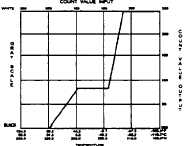
Figure 1-A
IN ANSWERING QUESTION 1-16, REFER TO
FIGURE 1-A.
1-16.
1-17.
1-18.
What type of enhancement curve is
depicted?
1.
Single
2.
Split
3. High-low
4.
MB pre-defined
A temperature scale is superimposed over
the gray-scale at the top of most GOES
infrared images. What is the temperature
interval of these lines?
1. 1°C
2.
2°C
3.
5°C
4 .
10°C
Which of the following types of imagery is
available via NODDS?
1. DMSP
2 . GOES
3. METEOR
4 . METEOSAT
2


