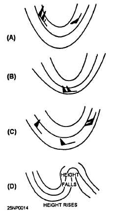
Figure 2-1.-Effect of super gradient winds on the deepening
and filling of troughs. (A) Strongest winds on the west side
of trough;(B) strongest winds in southern portion of trough;
(C) strongest winds on east side of trough; (D) excessive
contour gradients.
l Sharply curved ridges with excessive contour
gradients are unstable and rotate rapidly clockwise,
causing large height rises and filling in the trough area
downstream, and large height falls in the left side of the
strong gradient ridge [fig. 2-1, view (D)].
Convergence and Divergence Above
500 Millibars
Study the 300-mb (or 200-mb) chart to determine
areas of convergence and divergence. Note these areas
of convergence and divergence.
Convergence and divergence are covered in chapter
1 of this TRAMAN, and also in the AG2 TRAMAN,
volume 1. As a review of the effects of convergence and
divergence, and the changes in intensity of troughs and
ridges, we have the following rules:
Refer to chapter 1 for illustrations of these rules.
. Divergence and upper height falls are associated
with high-speed winds approaching cyclonically curved
weak contour gradients. Divergence results in height
falls to the left of the high-speed current.
. Convergence and upper height rises are
associated with low-speed winds approaching straight
or cyclonically curved strong contour gradients and with
high-speed winds approaching anticyclonically curved
weak contour gradients.
FORECASTING THE MOVEMENT OF
UPPER LEVEL FEATURES
The movement of upper level features is discussed
in the following text.
Movement of Highs
Areas of high pressure possess certain
characteristics and traits. The following text discusses
these indicators for areas of high pressure.
S E M I P E R M A N E N T H I G H S . — T h e
semipermanent, subtropical highs are ordinarily not
subject to much day-to-day movement. When a
subtropical high begins to move, it will move with the
speed and in the direction of the associated long wave
ridge. The movement of the long wave ridge has already
been discussed. Also, seasonal movement, though
slower and over a longer period of time, should be
considered. These highs tend to move poleward and
intensify in the summer, and move equatorward and
decrease in intensity in the winter.
BLOCKS.— Blocks will ordinarily persist in the
same geographic location. Movement of blocks will be
in the direction of the strongest winds; for example,
eastward when the westerlies are strongest, and
westward when the easterlies are strongest. The speed
of movement of these systems can usually be
determined more accurately by extrapolation,
Extrapolation should be used in moving the highs under
any circumstance, and the results of this extrapolation
should be considered along with any other indications.
Some indications of intensity changes that are
exhibited by lower tropospheric charts (700-500 hPa)
are as follows:
l Intensification will occur with warm air
advection on the west side; weakening and decay will
occur with cold air advection on the west side; and there
is little or no change in the intensity if the isotherms are
symmetric with the contours. This low tropospheric
advection is not the cause of the intensity change but is
only a indicator.
The cause is at higher levels; for
2-5


