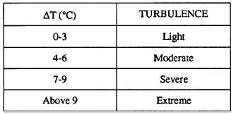
Table 5.3.-Relation of Maximum Positive Departure to
Thunderstorm Turbulence
OBSERVATION OF SEVERE WEATHER
FEATURES USING DOPPLER RADAR
Doppler radar (WSR - 88D) is proving to be a boon
to the forecasting of severe weather features, such as
wind shear, turbulence, and microbursts. For a
discussion of these topics, refer to the Federal
Meteorological Handbook No. 11, Doppler Radar
Meteorological Observations, Part D, as well as
chapter 12 of this manual.
SUMMARY
In this chapter we first discussed phenomena
associated with thunderstorms; and then followed with
a discussion of associated hazards aloft and at the
surface.
Methods used in the forecasting of
thunderstorm movement and intensity were discussed.
Following the discussion of thunderstorms, we covered
tornadoes, tornado types, and waterspouts. A discussion
on fog formation, types of fog, conditions necessary for
various types of fog, and the use of the Skew T Log P
Diagram in determining various fog parameters were
presented. Next, we covered the processes involved in
aircraft icing, intensities of icing, icing hazards near the
surface, and aloft. Operational aspects of aircraft icing
were then discussed, followed by types of icing and
icing intensity forecasts. The last topics presented were
turbulence characteristics, classification and intensities,
the forecasting of turbulence near the surface, in-cloud,
and CAT, as well as a discussion of the benefits of
Doppler radar in forecasting turbulence.
5-39


