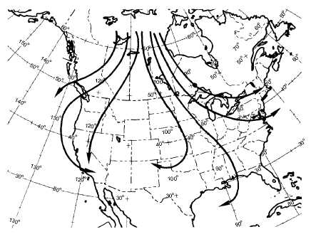
shown in figure 4-5. In the mid-latitudes, for an air mass
to be classified as arctic, the surface temperature is
generally 0 degrees Fahrenheit (-18 degrees Celsius) or
below.
TRAJECTORY
PATHS
A
AND
B
(CYCLONIC).—Paths A and B (fig. 4-5) are usually
indicative of a strong outbreak of cold air and surface
winds of 15 knots or more. This wind helps to decrease
the stable conditions in the lower levels. If this modified
air moves rapidly over rough terrain, the turbulence
results in low stratocumulus clouds and occasional
snow flurries (see fig. 4-6).
A particularly troublesome situation often arises
when the cold air flows from a cold, snow-covered
surface to a water surface and then over a cold,
snow-covered surface again. This frequently happens
with air crossing the Great Lakes. (See fig. 4-7.)
4-8
110O
40O
110O
G
B
A
C
D
F
E
AG5f0405
Figure 4-5.—Trajectories of cP and cA air in winter.
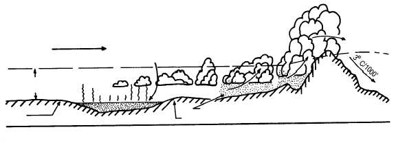
C
P
20 TO 30 MPH
TURBULENCE
SNOW
FLURRIES
CLEAR AND COLD
N
S
AG5f0406
Figure 4-6.—cP air moving southward.
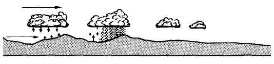
C
P
TEMP.
DIFFERENCE + 10 F
O
TEMP.
2000' 10 F
O
MOISTURE AND
WARM
AIR RISING
O
SURFACE TEMP. 0 F
NW
SE
WATER TEMP. 34 F
O
SURFACE TEMP. 21 F
O
CLEAR
SNOW FLURRIES
APPALACHIAN
MOUNTAINS
10 F
O
AG5f0407
Figure 4-7.—cP air moving over the Great Lakes (winter).