This pattern of subdividing the squares and
identifying the point with successively smaller
columns, and then row numbers may continue
indefinitely, but is normally only carried out to the
nearest lo-meter square for a precision targeted
position. A 10-meter position would have eight digits
following the letters, such as 34PDM 76673168, as
shown in figure 4-3, view D. To read this position,
mentally divide the number into two groups of four
digits (7667 / 3168). Think of it as moving eastward
from the west side of the DM 100,000-meter grid
boundary by (7) 10,000-meter-square subgrids, then (6)
1,000-meter-square grids, then (6) 100-meter-square
grids, then (7) lo-meter-square grids. Then, move
northward from the southern boundary of the DM grid
(3) 10,000-meter grid squares, then (1) 1,000-meter grid
square, then (6) 100-meter grid squares, and then (8) 10-
meter grid squares.
When military units pass positions in message
traffic within a region, frequently the grid zone
designation is left out of the position, such as DM
40132879. This practice is common within NATO
military forces in Europe.
Now let’s look for a moment at figure 4-4. Since the
east and west boundaries of each grid zone are specified
longitude lines and the 100,000-meter squares (fig. 4-3,
view A) are actual distances on earth, the 100,000-
meter squares along the edges of each grid zone overlap
as the longitude lines converge near the poles.
Overlapping portions are truncated at the grid zone
boundaries, and the charted grid zones appear to have
some partial 100,000-meter squares. When identifying
locations, remember that the lettering or numbering
system assumes that the missing or partial portions of
the 100,000-meter squares are intact.
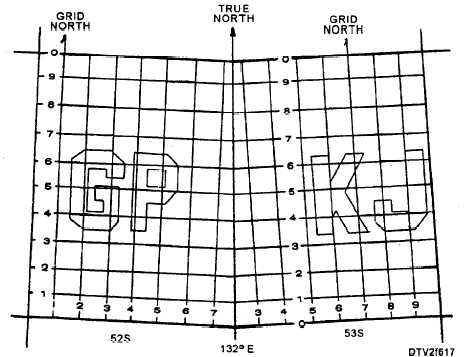
Notice that the 100,000-meter grid lines are only
parallel to the longitude lines near the center of each
grid zone. This means the grid lines are oriented
slightly westward of true north in the east half of a grid
zone, and eastward of true north in the west half of a grid
zone. The grid column lines are used as a reference
called "grid north" (GN).
The UTM grid lines drawn on a chart depend on the
scale of the chart. Figure 4-5 shows a portion of a
coastal chart with grid lines drawn every 200 meters.
On this chart, the grid location may be easily estimated
to the nearest 10 meters. Based on the latitude and
longitude, the grid zone is 20Q and the 100,000-meter
square is PC. The numbers indicate the 10,000-meter
grid coordinates. The lower-left comer of the box
marked M is 20QPC 40401040.
While the grid zone designation and the letters of
the 100,000-meter square may be used to approximate
the general area of a UTM location in geographical
coordinates, precise conversions of UTM grid
coordinates to geographical coordinates must be done
by referencing the UTM position on a gridded chart, and
Figure 4-4.—Partial 100,000-meter squares at edges of grid zones.
4-5